 SmartOne Solar
 SmartOne C
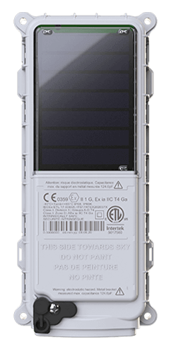
 ST100
ST100 STX3
STX3 STX3 Dev Kit
 SPOT X
 SPOT Gen4
 SPOT Trace
Calibrating Offshore Radar for NOAA
Woods Hole Oceanographic Institution
THE CHALLENGE
For more than a decade, the National Oceanic and Atmospheric Administration (NOAA) has operated a chain of radar stations lining the coast of the United States. Their targets are not ships or aircraft above the waves but the water itself. Using doppler technology, the radar is able track the direction and speed of surface ocean currents.
Why all this effort to track moving water? Every ocean swimmer understands how powerful a current can be. Knowing where currents will take a floating object is critical to the Coast Guard’s mission of search and rescue, as well as the tracking of hazards from disabled vessels and lost cargo containers to oil spills.
For all its usefulness, however, doppler radar is not perfect. The passage of a large ship distorts the radar return signal. The gigantic towers and moving blades of offshore wind farms may do the same. The more intensively we use our coastal waters, the less accurate radar tracking becomes.
THE SOLUTION
The Woods Hole Oceanographic Institution (WHOI) in Massachusetts is a nonprofit organization dedicated to ocean research, exploration and education. It won a grant from NOAA to conduct a study of currents in Massachusetts Bay, Nantucket Sound and the Gulf of Maine for comparison with doppler radar data.
The project focused on understanding the impact of the Vineyard Wind 1 installation off the island of Martha’s Vineyard. When completed, this project will consist of 63 wind turbines spaced one nautical mile apart in waters 35 miles off the Massachusetts mainland. The start of construction provided a natural experiment: a chance to test the accuracy of doppler radar in tracking currents both before and after wind turbines rise on the site. Should the study reveal lasting impacts on accuracy, it will inform what NOAA does in response.
The researchers built “drifters” – simple structures made of wood and cloth that floated with the current. They equipped each with a battery powered SmartOne C GPS tracker from Globalstar and launched ten drifters at a time. Each transmitted its GPS position for an average of two weeks before wave action pulled them apart and sank them.
The position data traveled over the Globalstar Satellite Network for display on SPOT My Globalstar, a digital mapping application. The WHOI scientists plotted the GPS data, indicating drift speed and direction, against the radar data provided by NOAA to test the accuracy of the doppler radar calculations.
WHOI selected Globalstar technology because of the simplicity, small size and low power consumption of the SmartOne C, and the affordability reliability of the Globalstar Satellite Network for short-messaging applications.
ABOUT WOODS HOLE OCEANOGRAPHIC INSTITUTION
The Woods Hole Oceanographic Institution in Massachusetts is one of the world’s most famous nonprofit organizations dedicated to ocean research, exploration and education. Its record of major milestones includes locating the wreck of the Titanic in 1985 and discovering previously unknown formations on the ocean floor: hydrothermal vents where life thrives in the deep dark.